Geoscience data capture · Est. 2001

Your legacy data holds the next target.

IndiGEO turns historical maps, drill logs, geochemical and geophysical surveys into structured, GIS-ready datasets. Our AI-driven, Human-in-the-Loop (HITL) workflow accelerates capture - with every dataset verified by geoscientists before delivery.

20Geoscientists
25 yrsIn exploration
100%SME-verified
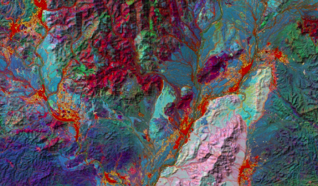
Sentinel-2 false-colour composite showing lithological discrimination and alteration analysis Sentinel-2 Lithological Discrimination and Alteration Analysis
How it works

Fast where machines are fast. Careful where it counts.

Automated extraction gets through volume; it struggles with faded contours, handwritten scrawl and geological ambiguity. Our human-in-the-loop workflow pairs the two - so you get speed without ever trading away confidence in the data.

01 - CAPTURE

AI-accelerated extraction

Scanned maps, sections, logs and reports are digitised using automated capture tools tuned for geoscientific context - handling the bulk at a pace manual entry can't match.

02 - VERIFY

Validated by subject-matter experts

Each dataset is checked, corrected and validated by an SME before delivery. Lithology codes, coordinates, assay intervals - signed off by someone who understands the geology.

03 - DELIVER

GIS-ready, overnight

Structured outputs in the formats you already use - GeoPackage, CSV, relational databases - schema-aligned and ready for modelling, targeting and portfolio decisions. For our clients in the Americas, our production day runs while you sleep - send at close of business, it's back by morning.

What we do

From paper archive to exploration-ready database.

We pair advanced GIS automation with human expertise. Every deliverable undergoes rigorous quality checks and receives a geoscientist's final approval before release.

Digitization

Verified historical data capture

Geology, geochemistry, geophysics and drilling records recovered from any source - from handwritten field notes to scanned regional maps.

  • Lithological units, contacts & structure
  • Drill logs, assays & geotech records
  • Geophysical maps and sections & wireline logs (LAS)
Databases

Data value enhancement

Raw digitized data compiled into structured, relational databases - statutory-compliant and formatted for modern analytics pipelines.

  • Database compilation & management
  • Standardised geological classification
  • Model-ready, schema-aligned outputs
Spatial

Georeferencing & spatial validation

Maps of any vintage located with quantified accuracy - even with no coordinate annotation, using feature matching against modern satellite imagery.

  • Prospect to regional scale
  • Documented positional confidence
  • Full transparency on data reliability
Geophysics

Processing & interpretation

Ground and airborne datasets re-processed with modern computational techniques to sharpen targets and improve subsurface visualisation.

  • 2D & 3D inversion modelling
  • Magnetics, EM, gravity, IP/resistivity
  • Legacy survey re-processing
Field

Ground geophysical surveys

IndiGEO owns and operates a broad selection of geophysical equipment, enabling surveys customised to your target and terrain.

  • Ground magnetics & EM
  • IP & resistivity surveys
  • Survey design through interpretation
Reporting

Cartography & statutory reporting

Professional map generation and comprehensive report writing, meeting or exceeding government requirements and industry standards.

  • Publication-quality map production
  • Statutory & technical reports
  • Deliverables in your house style

Explore services in detail

Before & after

Bringing legacy data to life.

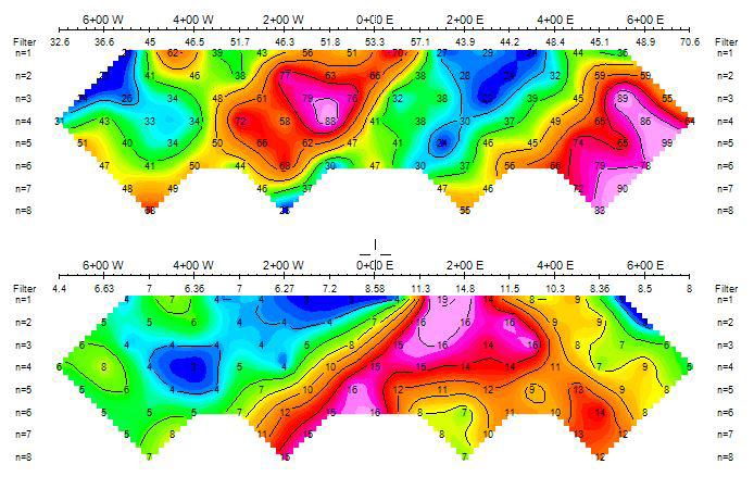
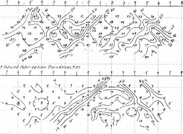
A hand-drawn IP pseudosection from a 1970s survey - uninterpretable in its original form, now digitised, re-plotted and ready for modern 2D inversion modelling.

Before - 1970s field original Hand-drawn induced polarisation pseudosection from a 1970s survey
✓ After - inversion-ready The same IP data digitised and re-plotted as coloured pseudosections ready for 2D inversion

See all case studies

Why IndiGEO

Bridge the gap between yesterday's insights and today's targets.

20

Dedicated geoscientists

A Bangalore-based team of experienced geologists, geophysicists and data specialists - not a general-purpose data-entry bureau.

100%

Every dataset SME-verified

Nothing ships on automation alone. Each dataset is reviewed and signed off by a geoscientist, with QC documented and traceable.

+10 hrs

Overnight turnaround for the Americas

Bangalore is half a day ahead of North and South America. A full production shift runs while you sleep - data sent at close of business in Toronto, Denver or Santiago is finished and on your desk by morning.

2001

A quarter-century in exploration

Grass-roots to advanced projects across all continents - we know what explorers need, because it's what we do.

What's sitting in your archive?

Send us a sample - a scanned map, a box of drill logs, an old survey. We'll return a free assessment of what it would take to make it work for you.

Request a free assessment